- Home
-
Day tours
- Day tours
-
Marsa alam tours
-
Hurghada tours
-
El Quseir Tours
-
Makadi bay
-
Cairo Tours
- Cairo Tours
- Top Things in Cairo
- Siwa tours from Cairo
- Cairo Culture Tours
- Alexandria trips from Cairo
- Nile Cruises From Cairo
- Night Dinner Cruises in Cairo
- Sound and Light show Excursion
- Fayoum trips from Cairo
- Luxor Tours From Cairo
- white desert trips from Cairo
- Al Minya tours from Cairo
- Cairo Travel Packages
- Cairo Desert and Safari tours
- Aswan tours From Cairo
- Cairo Taxi Transfers
-
Luxor Tours
-
Portghalib tours
-
Sharm el Sheikh
-
El Gouna Tours
-
Aswan Tours
-
Sahl Hasheesh Tours
-
Soma Bay tours
- Safaga Tours
-
Airport Transfer
-
Tour Packages
- Tour Packages
-
Egypt Travel Packages
- Egypt Travel Packages
- Egypt Itinerary 4 Days
- Egypt Itinerary 5 Days
- Egypt Itinerary 6 Days
- Egypt itineraries 7 Days
- Egypt itineraries 8 Days
- Egypt Itinerary 9 Days
- Egypt Itineraries 10 Days
- Egypt Itinerary 11 Days
- Egypt Itineraries 12 Days
- Egypt Itineraries 13 Days
- Egypt Itineraries 14 Days
- Egypt Itineraries 15 Days
- Egypt Itineraries 16 Days
- Egypt Itineraries 17 Days
- Egypt Itineraries 18 Days
- Egypt Itineraries 19 Days
- Egypt Itineraries 20 Days
- Egypt Itineraries 21 Days
- Top Egypt Vacation Packages
- Egypt Cruises Packages
- Egypt Christmas Holidays
- Hurghada Holiday Packages
- Marsa Alam holidays packages
- Marsa Alam tour Packages
- Egypt Walking Holidays
-
Shore Excursions
- Egypt Nile Cruises
-
Egypt Attractions
- Egypt Attractions
-
Top Attractions In Luxor
-
Top attractions in Bahariya
-
Top Attractions In Fayoum
-
Top Attractions In Siwa
-
Top attractions in Sakkara
-
Top Attractions In Giza
-
Top Attractions In Aswan
-
Top Attractions In Alexandria
-
Top Attractions In Cairo
-
Attractions in Damietta
-
Top Attractions In Hurghada
-
Top Attractions in El Quseir
- Top attractions in Marsa Alam
- Top attractions in Al Minya
- Top attractions in El Gouna
- Top attractions in Sharm
- Contact us
-
Egypt Travel Guide
- Egypt Travel Guide
- Egypt tours Faq
- Egypt Itinerary 7 Days
- Best Tours in Marsa Alam
- Egypt Itinerary 8 Days
- Travel to siwa from Cairo
- Plan your trip to Egypt
- Is Egypt Safe to Visit
- Egypt Itinerary Planner
- The Best Winter Destinations
- Egypt Tour Packages guide
- The best Nile Cruises in Egypt
- Tips For visiting the Pyramid
- Foods You Need to Eat In Egypt
- The 10 Best Marsa Alam Tours
- Payment Policy
- White desert Tour packages
FORTRESS OF SHALI
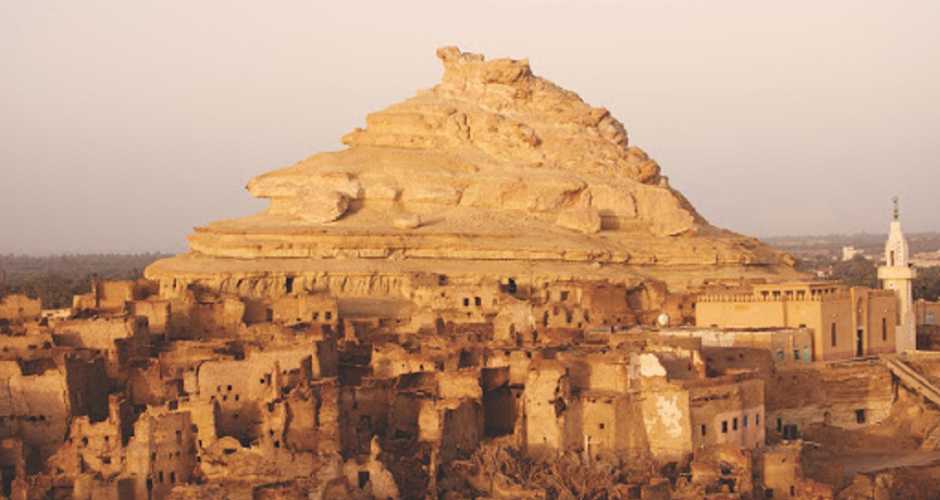
The fortification of Shali is located in the center of modern Siwa in the Siwa Oasis, and is basically the old town. Some of the buildings of the old town are even still in use, but due to their construction of salt, mud, rock and plaster they fall more into ruin each year. In fact, up until some extreme rain in 1926, much of the old town was still in use. The area dates from the 13th century.

History
The Village dates back to the year 600H.-1203 A.D. Al- Idreesy mentioned it in his book “Nozhat al-Moshtaq” in 1154 A.D, and so did Ibn Doqmaq in his book “al-Intesaar” in 1391-1388 as “Santareyya”. “Shaly” in the Siwa language means city and the reason behind its construction was to create a shelter for the oasis and to protect it from the attacks of the Bedwins; the Barbar and the Westerners. It was constructed by 40 persons who were the remains of the oasis population. The village was dumped in 1826 after Mohammed Ali’s conquest and when security prevailed the ancient village gradually moved and another village was built outside the older one. In 1826 heavy rain destroyed the village houses that were built with kershef and that lead to abandon the old village. Pharaonic and Roman tombs were found in the plateau and they were discovered by Ahmed Fakhry in 1937.

Description of archaeological content
The village is a prototype for the traditional desert architecture in the Western Desert, an architecture that resembles in its characteristics the city of Balat in Dakhla and the architecture of al-Kasaba in Morocco. The village now is remains of Kershef buildings. The best part of the village is its western part which is still inhabited. The village combines remains of houses, shops, six wells and a sitting room where families were gathered in during funerals, weddings and in solving their disputes. The sitting room is a square area with benches and palm-trunks ceilings. Many narrow passages run through the village.
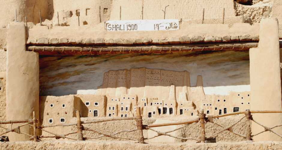
The eastern part includes the village remains and it is clear through the houses remains that they consisted of five or six stores. The ground flour usually consists of a reception hall, a store room, a room, a bath, an oven and a place for the cattle. The first floor however consists of a Durqaa, rooms and a bath while the upper flours consist of rooms, bath and a kitchen.Houses were constructed over the plateau’s amphitheatre and that is why they are not built with a well organized plan. From the top it looks like a honeycomb. The palm trunks were used as beams to fortify the buildings. The village buildings are surrounded by a defense enclosure wall. At first, the city had one door at the north side; its name was “Inshal Door”. After a century later, another door “Athrat” was opened at the southern side and it was used in the secret enter and exit when the village was under siege. A third door “Kaddouha” was opened and it was used by women only. The village was penetrated by narrow passages and paths for protection.Like any other Islamic city, a mosque was established for practicing the religious rituals and to be the main foundation in the city’s plan. The Ancient mosque had another role besides its religious one; its minaret was used as surveillance tower.
The village contains the “Tatandy” mosque and it is called “Sheikha Hossneyya Mosque” who donated a sum of money for its construction and it dates to the period when the village itself was established. The mosque is simple in its plan; it consists of a half circled socket with no ornaments. The minaret is built to the north of the mosque over a rectangular base topped by a conical shaft. The interesting thing is that restoration works tat are taking place in the time being are performed by the local people with the same old traditional way and under the supervision of the SCA.
